User manual
Everything the app does, screen by screen, with pictures. If something is not working the way you expect, the common problems page may have the answer.
Updated 12 October 2026. Screenshots use an example boat, Via Vita, on a passage from Rhodes to Marmaris.
- What the app is for
- Getting started
- Your boat profile
- Adding a position fix
- Typing positions
- Choosing a destination on the map
- The Dashboard
- OK, Watch and Concern
- The compass
- The barometer warning
- Cross-checks
- Forecast: the next 24 hours
- Planning a passage (pre-departure)
- Finding a harbour or anchorage
- The Log, editing and exporting
- Reminders and notifications
- At anchor: anchor alarm and weather watch
- Man overboard
- Emergency contacts
- Data sources
- Using an iPad
- Subscription and what is always free
- Your data and privacy
1. What the app is for
Med Sailing Weather gives you a plain-English read of the sea conditions where you are now and where you will be when you arrive, judged against what your boat finds uncomfortable. It is built for coastal sailing in the Mediterranean.
The idea is simple: every so often you log your position (a "fix"). The app then fetches the forecast for that spot and for your destination at your expected arrival time, checks the waves against your boat's comfort limits, and tells you whether things look fine, are worth watching, or are a concern.
2. Getting started
- Open the app. There is no account and no sign-in.
- Set up your boat on the Boat tab (see section 3). Nothing else works until a boat is saved.
- Allow notifications when asked, so the hourly fix reminder and the man overboard alert can reach you when the app is in the background.
- Allow location "While Using" if you want the GPS button to fill in your position. You can always type positions instead.
- Before you leave, use Plan a passage on the Dashboard to check the weather along your route and find the best time to go (section 13).
- Once underway, add a fix on the Add fix tab roughly every hour, then read the Dashboard.
The six tabs along the bottom are Dashboard, Forecast, Add fix, Harbour, Log and Boat.
3. Your boat profile
The Boat tab tells the app what your boat is and, most importantly, what sea conditions it finds hard. Every warning in the app is measured against these numbers, so it is worth a few minutes to set them up thoughtfully.
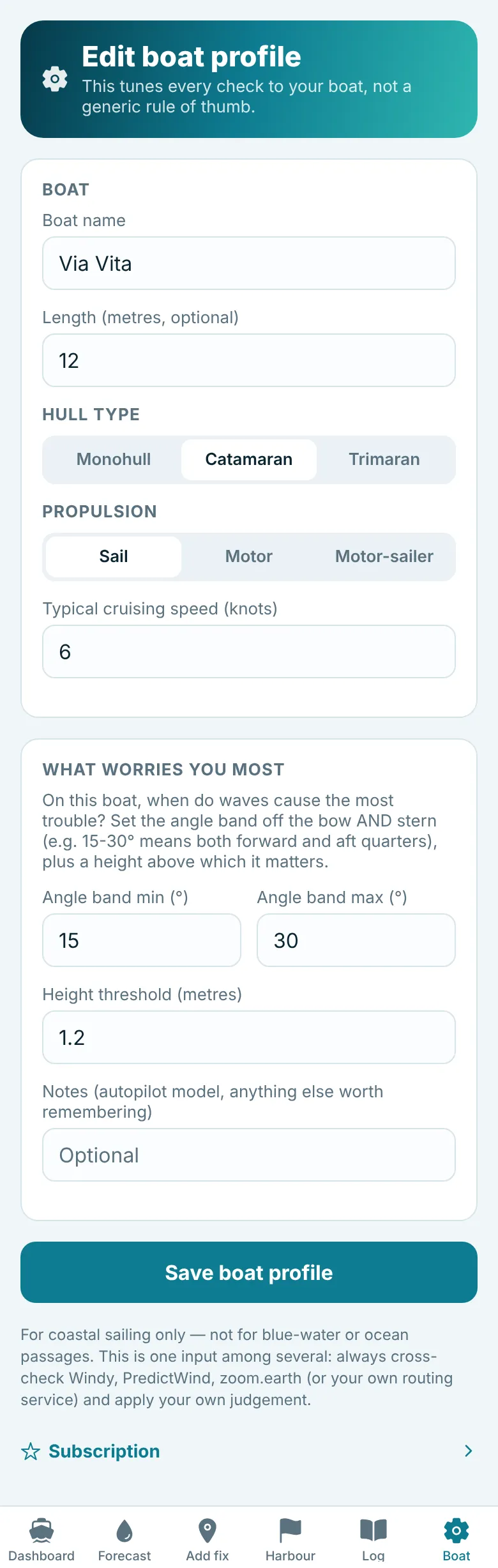
| Field | What it does |
|---|---|
| Boat name | Shown on the Dashboard and in the written reports. |
| Length | Optional, for your reference. |
| Hull type and propulsion | Monohull, catamaran or trimaran; sail, motor or motor sailer. |
| Typical cruising speed (knots) | Used to estimate your arrival time when you do not give a speed over ground with a fix (or it is under 0.5 knots). |
| Angle band min and max (°) | The range of wave angles your boat dislikes, measured off the bow and off the stern. See the diagram below. |
| Height threshold (metres) | The wave height above which you start to care. |
| Notes | Anything worth remembering, such as your autopilot model. |
The angle band, explained
Many boats, catamarans especially, handle waves from dead ahead or dead astern quite well but struggle when waves arrive at an angle on the quarter, where the autopilot has to work hard. The angle band describes that awkward zone. With a band of 15° to 30°, the app watches for waves coming from 15° to 30° either side of the bow and 15° to 30° either side of the stern.
If you are not sure what to enter, think back to the last time the boat was uncomfortable and roughly where the waves were coming from. You can change these numbers at any time. In the app, tap What are quartering seas, and what should I set here? on the Boat tab for a short explanation, or read Quartering seas, and your boat for how waves from different directions affect monohulls, catamarans and motor boats, with example settings.
4. Adding a position fix
A fix is your position, speed and course at a moment in time. It is the main thing you do in the app while sailing. Open the Add fix tab.
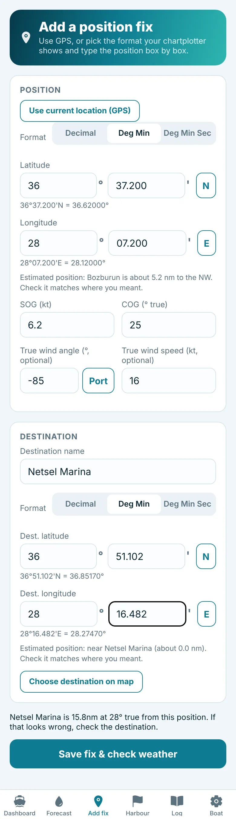
Position
- Tap Use current location (GPS) to fill in the position, or type it (see section 5).
- Choose the Format your plotter shows (Deg Min, the default, Deg Min Sec or Decimal) and type one unit per box. Under each box the app reads your position back, for example 36°37.200'N = 36.62000°. Check it matches your plotter.
- Below that, an estimated position line names the nearest marina, harbour or town, for example "Bozburun is about 5 nm to the NW". It is a quick sense check that you have not typed a wrong digit.
Speed, course and wind
- SOG (kt): speed over ground from your plotter or GPS.
- COG (° true): course over ground in degrees true, not magnetic. Your plotter's COG is normally true.
- True wind angle (optional): the angle of the true wind off the bow from your instruments. Type the angle as a plain number, with no minus sign, and use the Port / Stbd button beside it to say which side the wind is on. You can also type 85P or "85 port". The report then reads, for example, "TWA 85° port".
- True wind speed (optional): from your instruments.
If you give the wind readings, the app compares them with the forecast model and tells you whether they agree (section 11). Wind direction comparisons are skipped when either reading is under 6 knots, because light wind direction is unreliable.
Destination
On your first fix of a passage, type the destination name and position, or tap Choose destination on map (section 6). Before you save, a line under the form confirms the result, for example "Netsel Marina is 15.8nm at 28° true from this position." If that distance or bearing looks wrong, check the destination.
On later fixes the destination is remembered. Tap Plan changed? Update destination to change it. When the new destination is somewhere else, give it its new name as well; the app asks for this if the old name is still in the box. Moving to a new destination starts a new trip, so each trip keeps its own fixes and export.
Saving
Tap Save fix & check weather. The app records the fix, works out your progress since the last one, fetches the weather for now and for your arrival, and takes you to the Dashboard with a written report. The form clears ready for the next fix.
- If you save a fix at exactly the same position as your last one, the app asks whether you meant to. To correct a fix, use Edit in the Log instead.
- When a fix is within 1.5 nm of your destination, the app asks whether you have arrived and offers to end the leg.
- You do not need a final fix to end a trip: tap Arrived - end this trip on the Dashboard (see The Dashboard).
- If the weather check fails (often for lack of signal), your fix is still saved. Open it from the Log and tap Edit to re-run the check once you have a signal.
5. Typing positions
Positions can be typed in the format your chartplotter or chart app shows. Above every position there is a Format choice:
| Format | Boxes | Example |
|---|---|---|
| Deg Min (degrees and decimal minutes, as Navionics and most plotters show) | degrees, then minutes | 36 ° 49.520 ' |
| Deg Min Sec (degrees, minutes and seconds, as on some paper charts) | degrees, minutes, then seconds | 36 ° 49 ' 31.2 " |
| Decimal (decimal degrees) | one box | 36.8253 |
Pick the format once. The app remembers it, uses it in every position box, and shows positions in that format everywhere in the app. Type the numbers only, one unit per box, then use the N/S and E/W buttons for the hemisphere. In the Mediterranean that is almost always N and E.
Changing the format converts any position already filled in, so the position itself does not change. Positions are kept, shown on the map and exported in decimal degrees whatever you choose.
6. Choosing a destination on the map
Instead of typing a destination, you can point to it. This works for the destination on Add fix and for the arrival point on Plan a passage.
- Tap Choose destination on map (or Choose arrival point on map). A full-screen chart opens, centred on the destination you already typed, or on your boat.
- Pinch, or use the + and - buttons, to zoom in until you can see the harbour or anchorage clearly. Sea marks are shown on top of the map.
- Tap the spot. An orange pin appears and a panel asks "Is this the right destination?", showing the position in your chosen format and the nearest named place.
- Tap Use this point to fill in the latitude and longitude and close the map, or Choose again if you tapped the wrong place. Cancel at the top closes the map without changing anything.
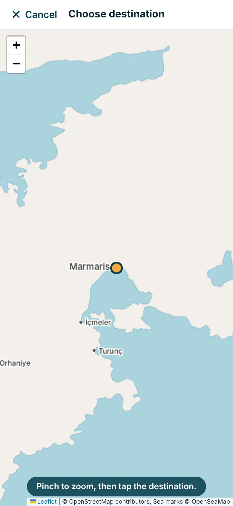
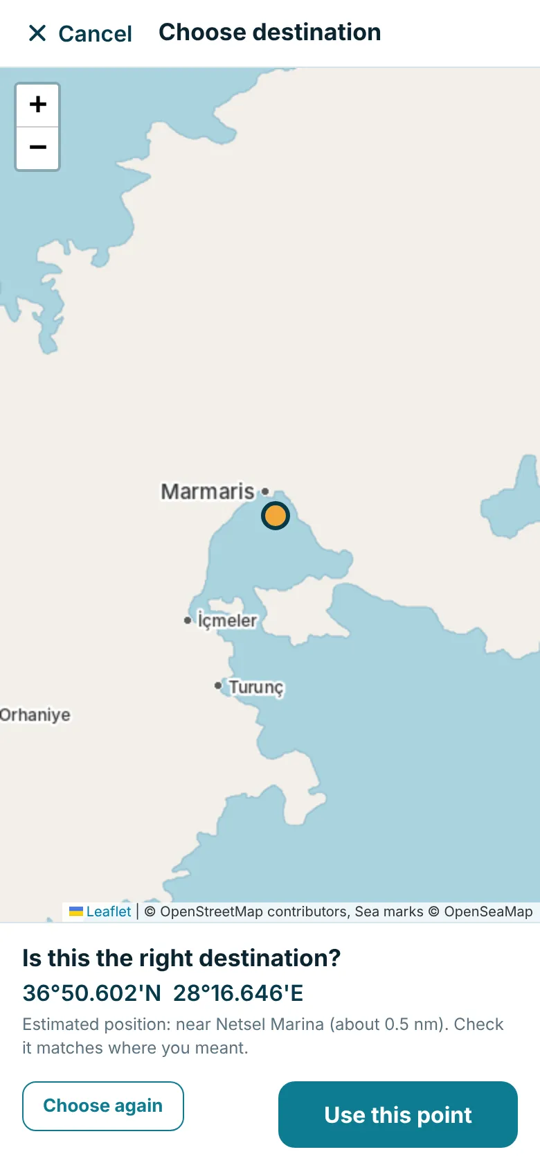
In the app the map shows coastlines, towns, harbours and sea marks from OpenStreetMap and OpenSeaMap; these example pictures show only the coastline and a few place names around Marmaris. The map needs a data connection. Always check the point against your chart before relying on it.
7. The Dashboard
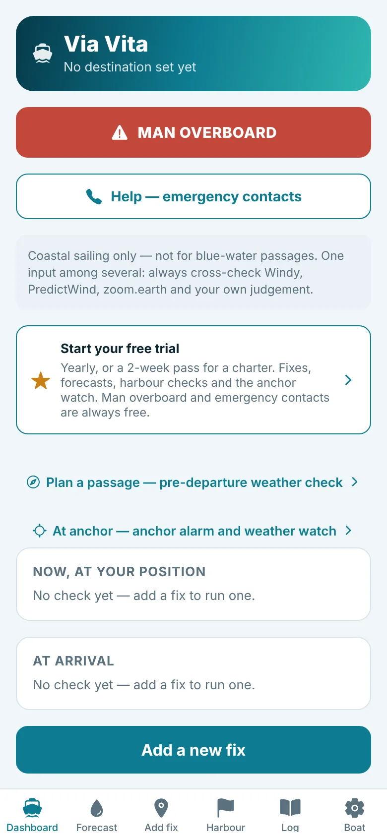
The Dashboard is the home screen. From top to bottom:
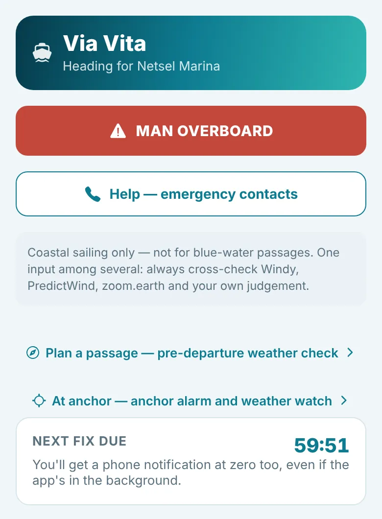
- Header: your boat and where you are heading.
- MAN OVERBOARD: the red button (section 17).
- Help, emergency contacts: phone numbers for the nearest coastguards (section 18).
- Plan a passage: the pre-departure weather check (section 13).
- At anchor: the anchor alarm and the weather watch (At anchor). While either is on, this line shows how it is going.
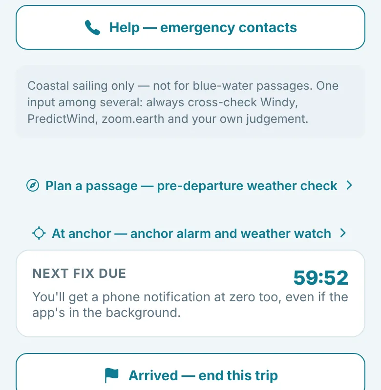
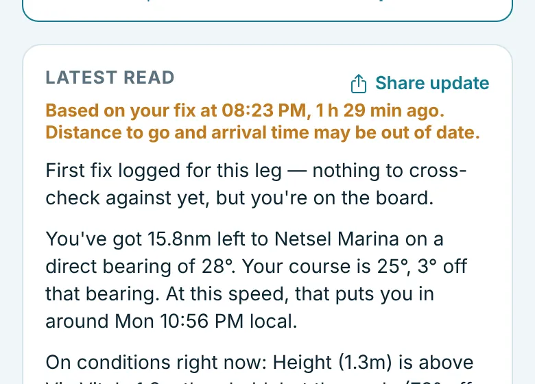
- Next fix due: a countdown to your next fix. At zero your phone also gets a notification. If your last fix is over an hour old, a banner says so, because distance to go and arrival time are worked out from that fix and do not update by themselves.
- Arrived - end this trip: shown while a trip is under way. Tap it when you arrive, confirm, and the trip ends and the fix reminders stop, without entering a final fix. Use it as soon as you are tied up, or the next passage's fixes will run on into the same trip. If you tap it by mistake, enter the destination again with your next fix.
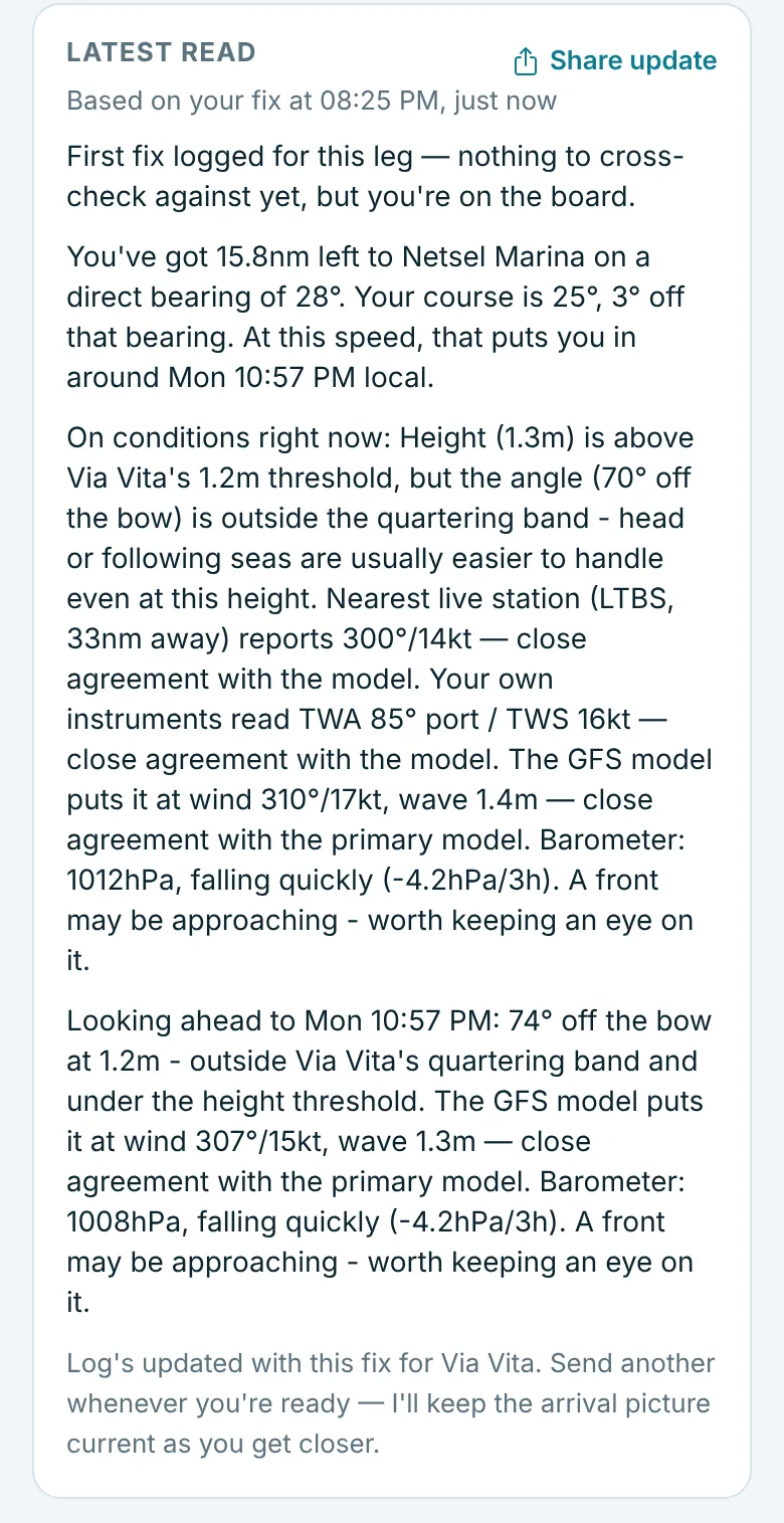
- Latest read: the written report from your last fix. Its first line says which fix it is based on and how long ago, for example "Based on your fix at 10:13, 25 min ago". After an hour the line turns amber and adds that distance to go and arrival time may be out of date. The report covers your progress, distance and bearing to go, estimated arrival, conditions now, conditions at arrival, the cross-checks and the barometer. Tap Share update to send it by message or email.
- Last fix: position, SOG and COG of your most recent fix.
- Now, at your position and At arrival: two cards with the conditions, each with its own urgency badge and compass.
- Support & feedback at the bottom opens this website.
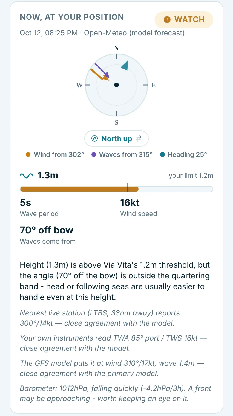
Each conditions card shows:
- the time and source of the forecast;
- an urgency badge: OK WATCH or CONCERN;
- the compass with wind, waves and your heading (section 9);
- the wave height, with a bar showing it against your limit (the tick mark);
- wave period and wind speed;
- where the waves come from relative to the boat, as one figure from the nearer end, such as "70° off bow" or "20° off stern";
- a one-paragraph explanation, then the cross-checks and the barometer reading in grey.
8. OK, Watch and Concern
The badge comes from two questions: are the waves coming from inside your boat's angle band, and are they at or above your height threshold? The app uses the wave direction; if there is no wave direction, it uses the wind direction instead.
| Badge | When | Example wording |
|---|---|---|
| CONCERN | Inside the angle band and at or above the height threshold. | "Quartering aft (20° off the stern) at 1.6m - inside Via Vita's configured risk band. Expect the autopilot to work hard; be ready to hand-steer." |
| WATCH | Inside the angle band but below the height threshold. | "Angle is in the quartering band ... but height is under the threshold - watch for it building." |
| WATCH | At or above the height threshold but outside the angle band. | "Height (1.3m) is above Via Vita's 1.2m threshold, but the angle (70° off the bow) is outside the quartering band." |
| WATCH | Something is missing (heading, direction or height), so the angle cannot be judged. | "Missing heading, wave/wind direction, or height - can't evaluate the angle band yet." |
| OK | Outside the angle band and below the height threshold. | "74° off the bow at 1.2m - outside Via Vita's quartering band and under the height threshold." |
The badge is about your boat's comfort limits, not about safety in general. A forecast OK does not mean conditions will be easy, and the forecast itself can be wrong.
9. The compass
Each conditions card has a compass showing three things:
- Wind: a solid orange arrow pointing the way the wind blows, drawn from the direction it comes from.
- Waves: a dashed purple arrow, drawn the same way, from the direction the waves come from.
- Heading: a teal triangle on the ring showing your course.
The legend underneath gives the exact figures, such as "Wind from 302°, Waves from 315°, Heading 25°". All directions are in degrees true.
North up or course up
Tap the button under the compass to switch between two views. Your choice is remembered.
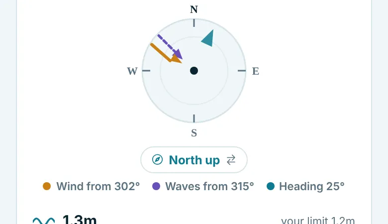
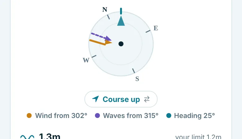
Course up makes it easy to see at a glance where the waves are hitting the boat. The button only appears when the app knows your heading.
10. The barometer warning
A fast-falling barometer is one of the oldest signs that a front or a blow may be on its way. The app keeps an eye on this for you.
What it does
With every fix, the app fetches the sea-level air pressure for your position, and for your destination at your arrival time. It compares the pressure with the reading three hours earlier and describes the change using the standard bands that ships and weather stations use.
over +6.0
+3.6 to +6.0
+1.6 to +3.5
+0.1 to +1.5
under 0.1
-0.1 to -1.5
-1.6 to -3.5
-3.6 to -6.0
below -6.0
When a warning is given
When the pressure is falling quickly (a drop of more than 3.5 hPa in three hours) or falling very rapidly (more than 6 hPa), the app adds one sentence: "A front may be approaching - worth keeping an eye on it." At any other rate of change, it simply reports the reading and the trend.
What it looks like
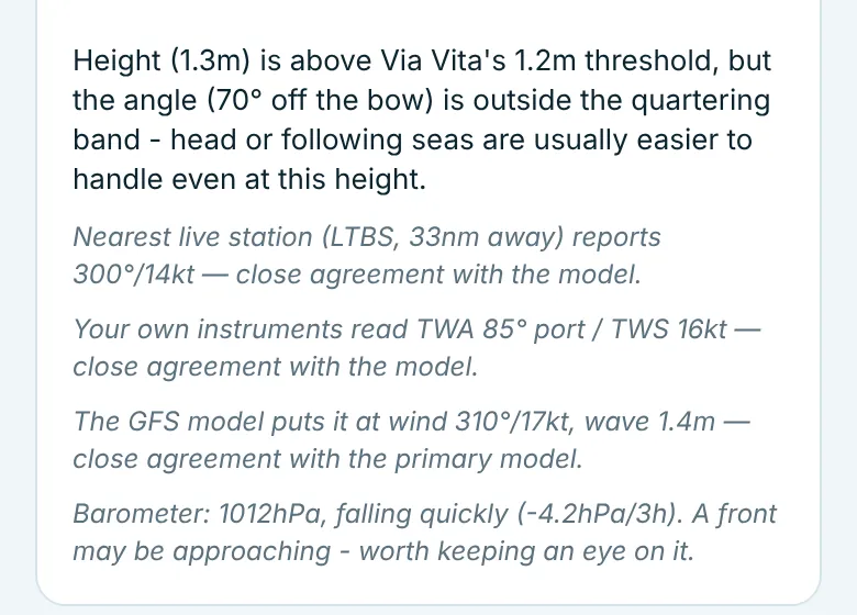
The barometer is a line of text, not a pop-up. It appears in two places: at the end of the Now, at your position and At arrival cards on the Dashboard, and in the Latest read report.
| Situation | What you see |
|---|---|
| Normal | Barometer: 1015hPa, falling slowly (-0.8hPa/3h). |
| Rising | Barometer: 1013hPa, rising (+1.9hPa/3h). |
| Warning | Barometer: 1012hPa, falling quickly (-4.2hPa/3h). A front may be approaching - worth keeping an eye on it. |
| Trend not available | Barometer: 1012hPa. |
Worth knowing
- The warning does not change the OK / Watch / Concern badge, which is about waves and your boat. Read the barometer line as extra information.
- It does not send a notification. You see it when you add a fix and read the Dashboard.
- The pressure comes from the forecast model (Open-Meteo), not from a barometer on your boat. For the arrival card, the trend is the model's forecast trend for that time.
- If your boat has a barometer, trust it. If the two disagree, the boat's reading is the real one.
- A falling barometer is a prompt to check the official forecast and warnings for your area, not a forecast in itself.
11. Cross-checks
No single forecast is perfect, so with each fix the app quietly compares its main forecast with up to three other sources and tells you whether they agree. These appear in grey under the explanation on each card, and in the written report.
- Nearest live station: the latest observed wind at the nearest airport weather station within about 60 nm, for example "Nearest live station (LTBS, 33nm away) reports 300°/14kt - close agreement with the model." Out at sea there may be none in range.
- Your own instruments: if you entered true wind angle and speed with the fix.
- A second forecast model (GFS, from the US weather service) for wind and waves.
When they disagree by a meaningful amount, the line ends with "Worth a look." That is a good moment to check another forecast.
12. Forecast: the next 24 hours
The Forecast tab projects your position forward along your course at your current speed and shows the conditions, hour by hour, where you will actually be. It stops at your destination rather than guessing beyond arrival.
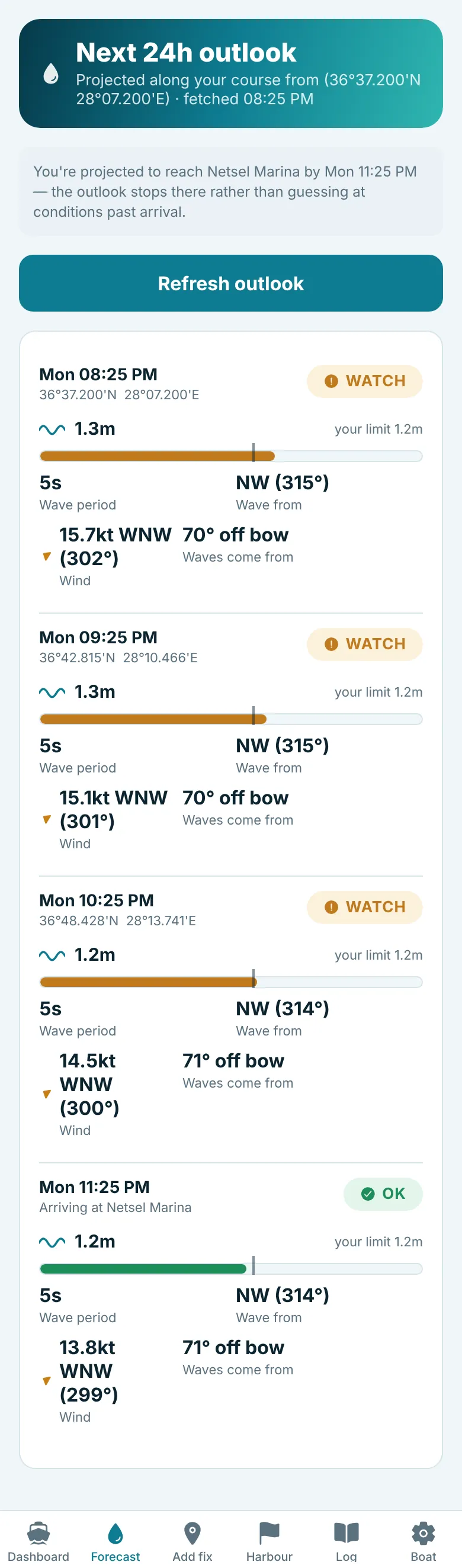
It needs at least one fix. Tap Refresh outlook to fetch it again.
13. Planning a passage (pre-departure)
Before you leave, tap Plan a passage - pre-departure weather check on the Dashboard.
- Enter the departure point name and position (on board, tap Use current location (GPS) to fill in the position), and your planned departure date and time. Times on this screen are UTC, which avoids confusion when crossing time zones.
- Enter the arrival point, or tap Choose arrival point on map, and your expected arrival time.
- Tap Check best window. The app scans the next 72 hours at your departure point against your boat's limits and suggests the clearest window, for example "Clearest window: Mon 12:00 - Tue 19:00 (32h, inside Via Vita's thresholds throughout)". Tap Use this departure time to copy it into the form.
- Tap Start pre-departure monitoring. You get a live report for departure, arrival and points along the route, each with its own badge.
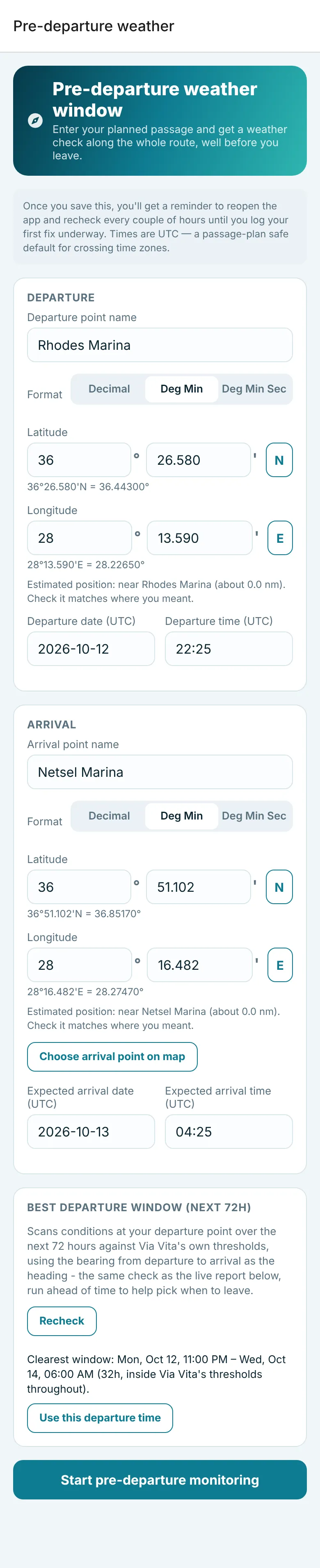
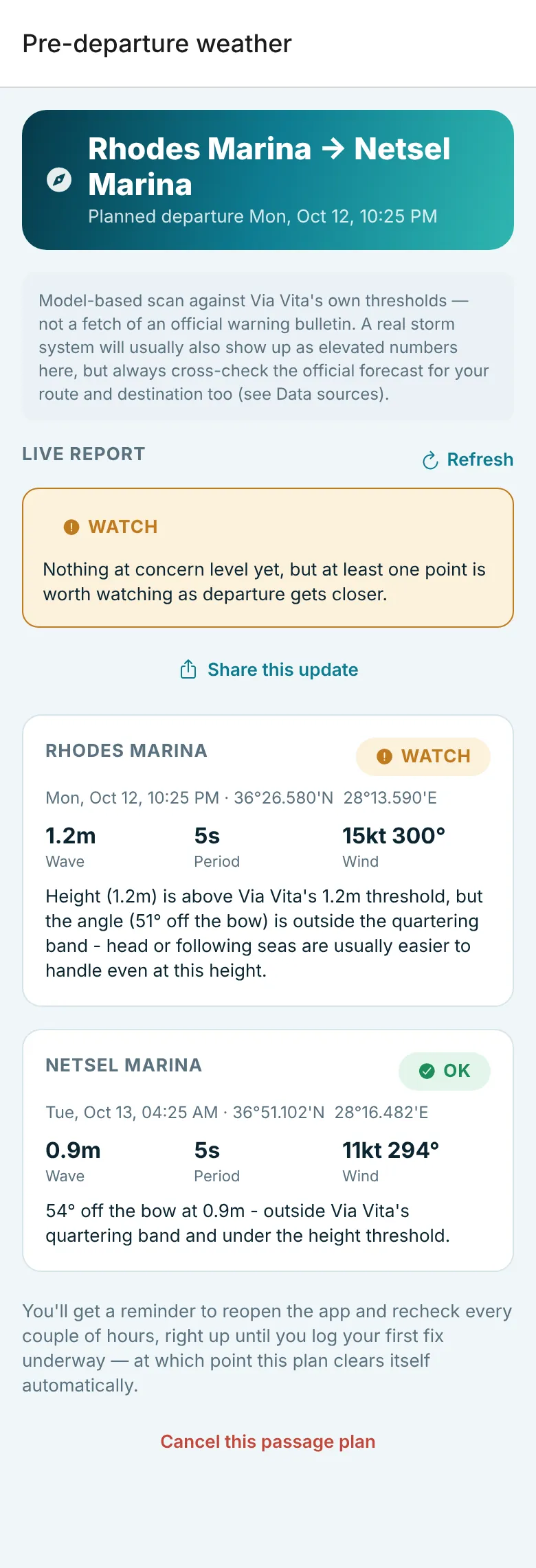
While a plan is active, you get a reminder every couple of hours to open the app and recheck, until your planned departure time. Tap Refresh for an updated report, or Share this update to send it to crew. To stop the reminders but keep the plan, tap Stop the reminders (keep this plan). The plan clears itself when you log your first fix underway, or tap Cancel this passage plan.
The latest report is kept on your phone, so you can read it at sea with no signal and compare it with the conditions you meet. If a refresh fails, the screen shows the saved report and when it was fetched. After your first fix has cleared the plan, open Plan a passage again and tap View the last report. It is the forecast as it stood when it was fetched, and it is not updated.
14. Finding a harbour or anchorage
The Harbour tab is for when conditions turn and you want to know where you could head. Enter a position (or tap Use last fix) and choose:
- Marinas: the nearest marinas within about 20 nm, with distance, bearing and any phone number, VHF channel or website listed in OpenStreetMap. Tap a position to open it on a map. Anywhere in the Mediterranean this works with no signal, from a list of more than 3,600 places to moor built into the app; the results note shows the date of the list. Outside the Mediterranean the app searches online instead.
- Anchorages: possible sheltered spots nearby, ranked by an estimate of which wind directions the coastline shelters them from. This needs a signal the first time you search an area; the coastline is then saved on the phone, so a later search nearby works offline.
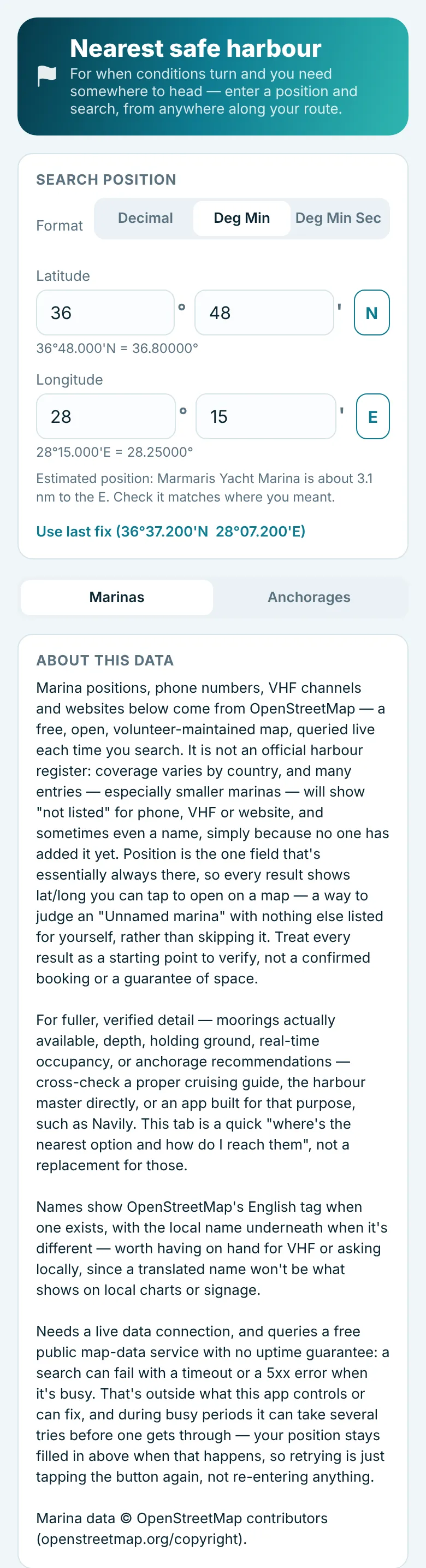
The results come from OpenStreetMap, a volunteer-maintained map. Coverage varies, smaller marinas may have no phone or VHF listed, and nothing here confirms that a berth is available. The list includes town harbours as well as marinas, and it does not always tell them apart. A private marina has staff to help you moor, laid mooring lines, controlled access, showers and toilets, and charges accordingly. A town harbour, which is what most places to moor in Greece are, is usually a public quay with a small fee, where you drop your own anchor well out and go stern-to, with no staff and few facilities. Treat each result as a starting point and check a pilot book or call ahead. The free map servers used for anchorages, and for marinas outside the Mediterranean, are sometimes busy; if a search fails, just tap the button again.
15. The Log, editing and exporting
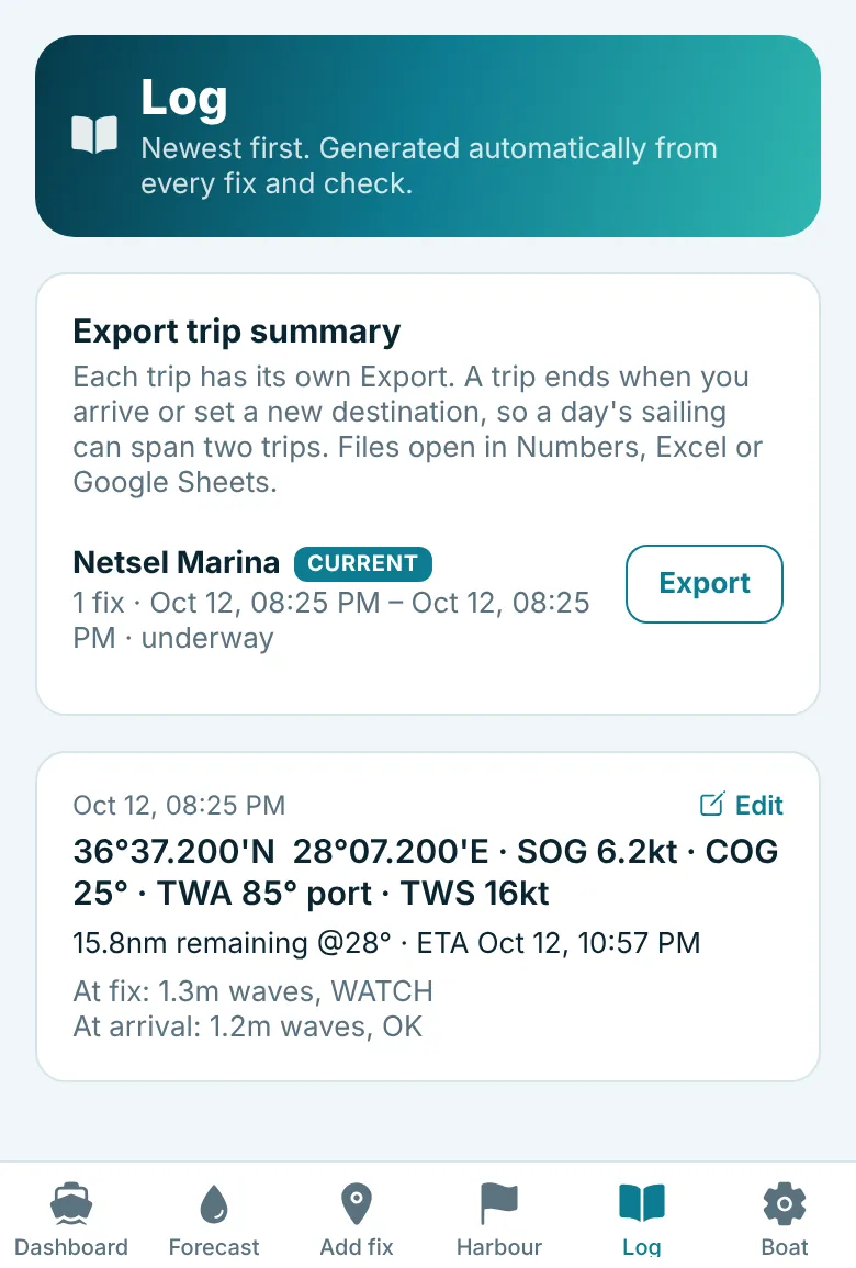
The Log tab lists every fix, newest first, with the progress since the previous fix, the remaining distance and arrival estimate, and the conditions at the fix and at arrival.
Correcting a fix
Tap Edit on any fix to correct a mistyped position, SOG or COG. The app recalculates that fix's progress and weather, and the next fix's progress if there is one. This is also how you re-run a weather check that failed for lack of signal.
Deleting a fix
If you saved a fix by mistake, for example by tapping Save instead of Use current location (GPS), tap Edit on it and then Delete this fix. It is removed from the Log and the trip export, and the next fix's progress is measured from the fix before instead.
Progress checks
The app compares the distance you covered between fixes with the speed you reported. If they do not match, for example "Implied speed 12.9kt vs reported SOG 6.0kt - check the fix", one of the positions is probably mistyped. Saving two fixes at the same spot gives an implied speed of 0.0 kt for the same reason.
Exporting a trip
Under Export trip summary, tap Export beside a trip to save all of that trip's fixes as a CSV file that opens in Numbers, Excel or Google Sheets, ready to keep, email or add to your own log. A trip ends when you arrive or set a new destination, so one day's sailing can be split across two trips. To get everything in one file, tap Export all trips in one file.
16. Reminders and notifications
| Notification | When |
|---|---|
| Time for a fix | One hour after your last fix: "It's been an hour since your last position fix - log a new one to keep the weather picture current." |
| Pre-departure weather check | Every two hours while a passage plan is active, until your first fix underway. |
| MAN OVERBOARD | Straight away when the man overboard button is pressed, with the captured position. |
| ANCHOR ALARM | When the boat is outside the swing circle or in your no-go sector, repeated every minute until silenced. |
| Low battery at anchor / LOW BATTERY AT ANCHOR | While an anchor watch is on and the phone is not charging: at 20%, then louder at 10%. |
| Weather warning / WEATHER ALARM AT ANCHOR | When the weather watch finds falling pressure or strong wind or waves ahead, repeated every 5 minutes until silenced. After you silence it, it sounds again only if something new or worse turns up. |
The fix and pre-departure reminders are set on your phone and work without a signal. Underway, the barometer and conditions are only updated when you add a fix or refresh; at anchor, the weather watch keeps checking for you.
At anchor: anchor alarm and weather watch
Tap At anchor on the Dashboard. The screen has two watches, each switched on separately: an anchor alarm that sounds if the boat moves outside a circle around the anchor, or into a no-go sector you mark, and a weather watch that sounds if pressure falls fast or strong wind or bigger waves are on the way. Both keep working with the phone locked, and can also send their alarms to another phone by Telegram.
Setting the anchor alarm
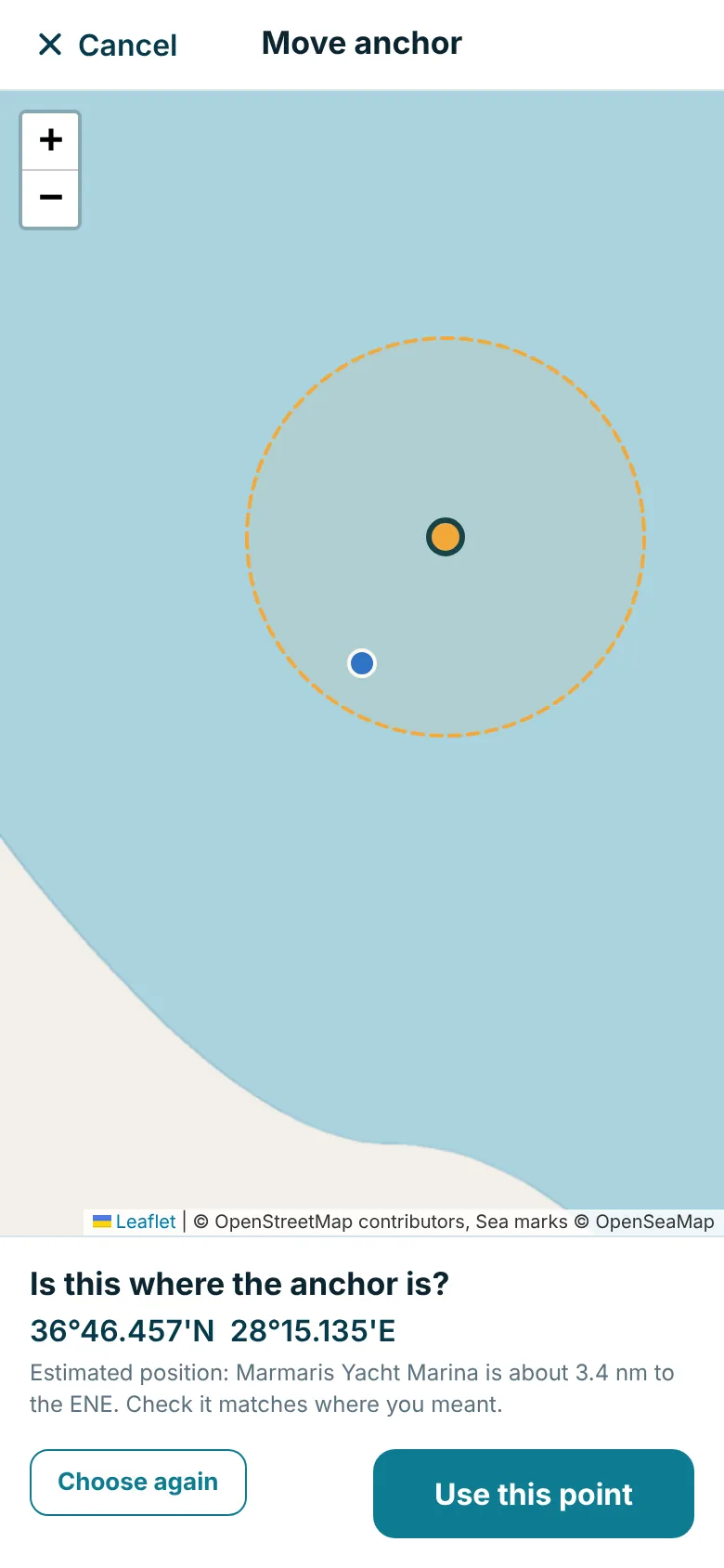
- Mark the anchor. Either tap Anchor dropped - use GPS position as the anchor goes down, while the boat is over it, or tap Choose anchor position on map and tap the spot on a close-up map of the anchorage. Your boat is the blue dot.
- Move it if needed. If the anchor dragged before it set, or you dropped it ahead of where you pressed the button, tap Move anchor position on map, tap the right spot, and confirm.
- Enter the chain out in metres.
- Enter the swing radius in metres: how far the boat may be from the anchor before the alarm sounds. The app suggests a figure from your chain and boat length; tap it to use it, or type your own.
- Tap Start anchor alarm and allow location "Always" (iPhone) or "All the time" (Android) when asked.

A no-go sector (optional)
If there is a side the boat must not swing towards, such as boats moored stern-to on one side, rocks or a quay, add a no-go sector. Tap Add a no-go sector, either while setting up or once the alarm is running and you can see how the boat lies, and enter:
- From bearing and To bearing: the bearings from the anchor towards the hazard, going clockwise from the first to the second. For boats lying to the north-west through north-east of your anchor, for example, enter 300 and 60. The screen shows the boat's present bearing from the anchor as a guide.
- Alarm in the sector beyond: how far from the anchor the boat may go in that direction before the alarm sounds.
The sector is shaded red on the plot, inside the green swing circle. The alarm then sounds if the boat goes outside the circle in any direction, or into the red sector beyond that distance. Close to the anchor, the whole circle is allowed, so the boat can lie over its anchor whichever way the wind blows.
Stern lines ashore. When you are tied back to the shore and the boat must not swing at all, make the sector everything except a narrow wedge towards the shore. For example, if the shore is at 180° from the anchor, enter From 195° and To 165° (going clockwise, that covers all the way round except 165° to 195°), with a distance well short of where the boat lies. The alarm then sounds as soon as the boat swings out of line.
While it is watching
The screen shows how far the boat is from the anchor, the furthest it has been, the GPS accuracy, and a plot of the circle with the boat's recent track. The phone checks its position about every 10 seconds.
If the boat is outside the circle on two readings in a row (so a single GPS jump does not wake you), the alarm sounds: a loud alarm tone and vibration while the app is open (even with the ringer switch on silent), an alarm notification with the same tone, repeated every minute, when the phone is locked, and a red ANCHOR ALARM banner on every screen. Tap Silence alarm once you are on deck: it stays quiet for 1 minute, then sounds again if the boat is still outside. If you have simply left the anchorage with the alarm still on, tap Turn off anchor alarm on the alarm itself and confirm. When you weigh anchor, tap Turn off anchor alarm under Leaving the anchorage? at the top of the At anchor screen; it turns off the weather watch too if that is on. If you forget and add a fix with either watch still on, the app asks whether to turn them off.

The weather watch
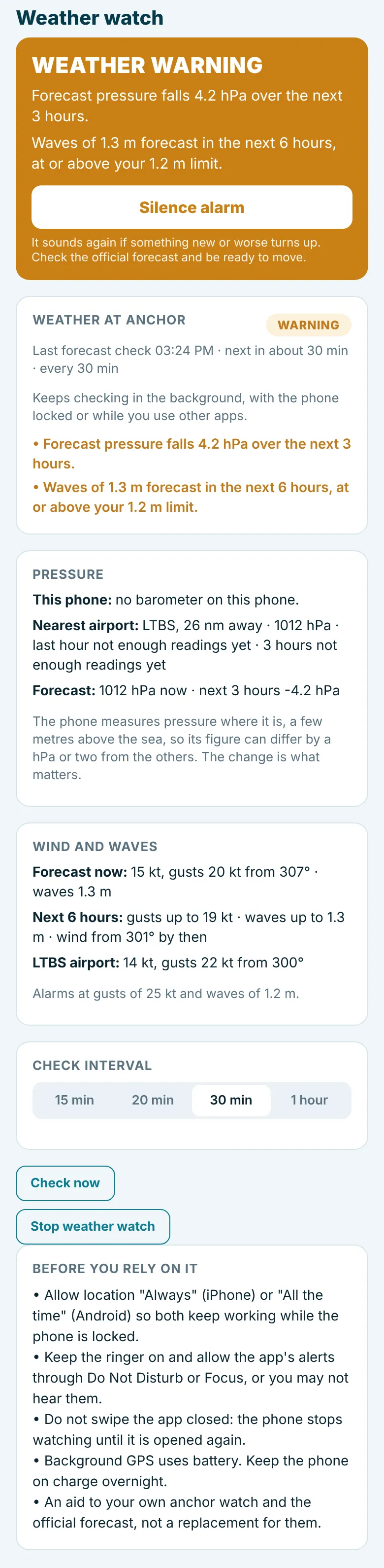
Choose how often to check the forecast, set your wind and wave limits, and tap Start weather watch. It checks the weather at the anchor (or your GPS position if no anchor is set). It sounds an alarm for:
| Sign | Warning | Serious |
|---|---|---|
| Pressure falling (on the phone's barometer, at the nearest airport, or in the forecast for the next 3 hours) | 1 hPa or more in an hour, or 3 hPa or more in 3 hours | 3 hPa or more in an hour, or over 6 hPa in 3 hours |
| Wind gusts, now or forecast in the next 6 hours | At or above your limit | 10 kt or more above your limit |
| Waves forecast in the next 6 hours | At or above your limit |
A forecast wind shift of 90° or more in the next 6 hours, which can leave an anchorage exposed, gives a quieter note rather than an alarm.
Changing the limits while it runs. Once you silence a wind alarm, it stays quiet while the gusts stay above your limit, and sounds again if they reach 10 kt over it. If the wind is already over your limit when you settle for the night, raise the limit in Alarm limits on the same screen and tap Save new limits, so you are woken only if it gets worse.
Once started, both watches carry on in the background at the interval you chose: with the phone locked and the screen dark, or while you use other apps. You do not need to keep the At anchor screen open. This needs location allowed "Always" (iPhone) or "All the time" (Android). If it is not allowed, the screen says in red that it is checking only while the screen is open, with an Allow background checks button that takes you to the setting.
How often to check
30 minutes is a good balance. The forecast and airport reports only update about once an hour, so checking more often adds little. Choose 15 or 20 minutes on a night when a front is expected. Whatever you choose, the phone's own barometer (most recent phones have one) is read every 5 minutes without using data. Most of the battery goes on keeping the GPS running in the background, not on the checks, so keep the phone on charge overnight.
Alarm messages on Telegram
The app can also send the alarms as Telegram messages to another phone: your own while you are ashore, or a crew member's. Messages go when the anchor alarm goes off (repeated every 5 minutes while it keeps going), when a weather alarm goes off, when the battery is nearly flat, and when the anchor alarm is switched on or off. Each anchor alarm message includes the boat's position and a map link. The alarm on the boat still sounds as usual.
Setting it up takes about five minutes, using a Telegram bot of your own. Under Alarm messages on Telegram on the At anchor screen, tap Set up Telegram messages and follow the steps:
- In Telegram, open @BotFather and send /newbot. Give the bot a name and a username ending in "bot". BotFather replies with a token, a long code like 123456789:AAH... Copy it.
- Paste the token into the app and tap Check token.
- On the phone that should get the messages, open your new bot in Telegram and tap Start. To reach several people, make a Telegram group, add the bot to it and send a message in the group. Then tap Find the chat in the app.
- Tap Send test message and switch on. The test message should arrive in Telegram straight away.
You can switch the messages off and on, send another test, or remove the set-up at any time. The token and chat are kept on the phone only; anyone with the token could send messages as your bot, so do not share it.
Low battery warning
While either watch is on, the top of the At anchor screen shows the phone's battery level. If the phone is not on charge, you get a notification at 20% and a louder alarm at 10%, because both watches stop when the phone switches off. The warning turns red on the screen at 20%. Plugging the phone in clears it.
17. Man overboard
The red MAN OVERBOARD button on the Dashboard immediately records your GPS position, sounds an alarm (vibration) and shows a notification. A red banner then stays at the top of every screen until the alert is cleared.
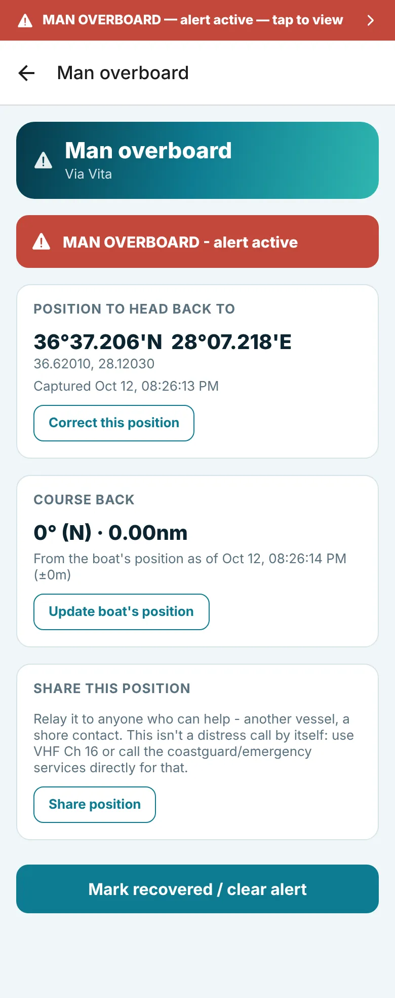
- Position to head back to: the captured position in degrees and minutes. Tap Correct this position if you need to type it.
- Course back: the bearing and distance from the boat back to that position. Tap Update boat's position for a fresh GPS reading.
- Share position: sends the position to another vessel or a shore contact by message.
- Mark recovered / clear alert: only once the person is safely aboard, or the button was pressed by mistake.
18. Emergency contacts
The Help - emergency contacts button opens maritime rescue phone numbers for Mediterranean countries, with the nearest first based on your last fix. Tap Use current GPS position to re-sort from where you are now. The screen also reminds you of the standard VHF and DSC distress procedure. Tap a number to call it.
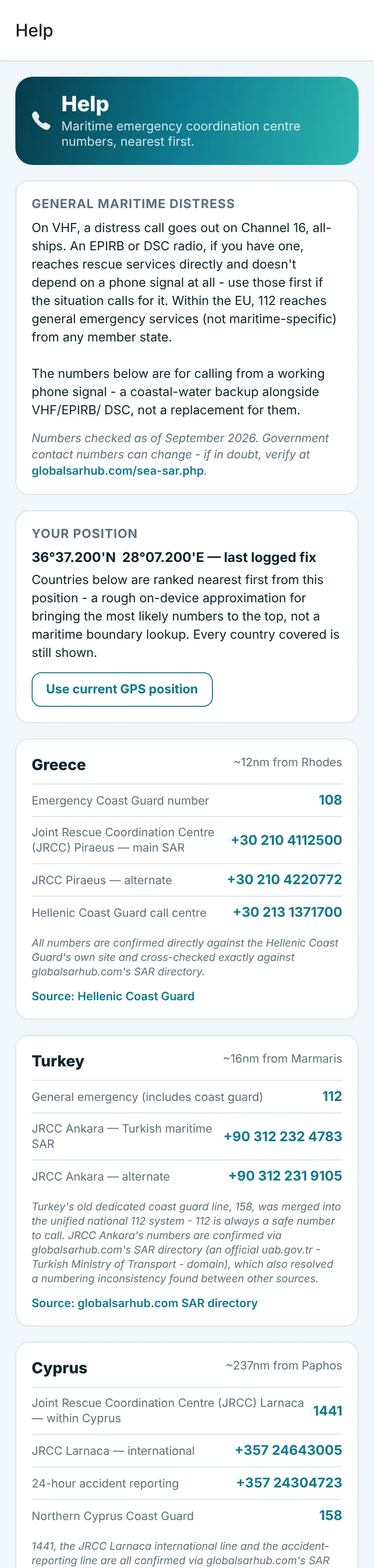
Numbers were checked against official sources but can change. It is worth confirming the numbers for your cruising area before you go.
19. Data sources
Reached from the bottom of the Dashboard, this screen explains where every number comes from, how often it is checked, and links to the official warning services for each Mediterranean country. It also has the Support & feedback link and a short list of limits worth knowing.

20. Using an iPad
The app runs on iPad and Android tablets as well as phones. On a tablet it turns to landscape as well as portrait, and on iPad it also works in Split View; on a phone it stays in portrait. On a large screen each page is shown as a single column down the middle, so the cards stay easy to read.
Subscription and what is always free
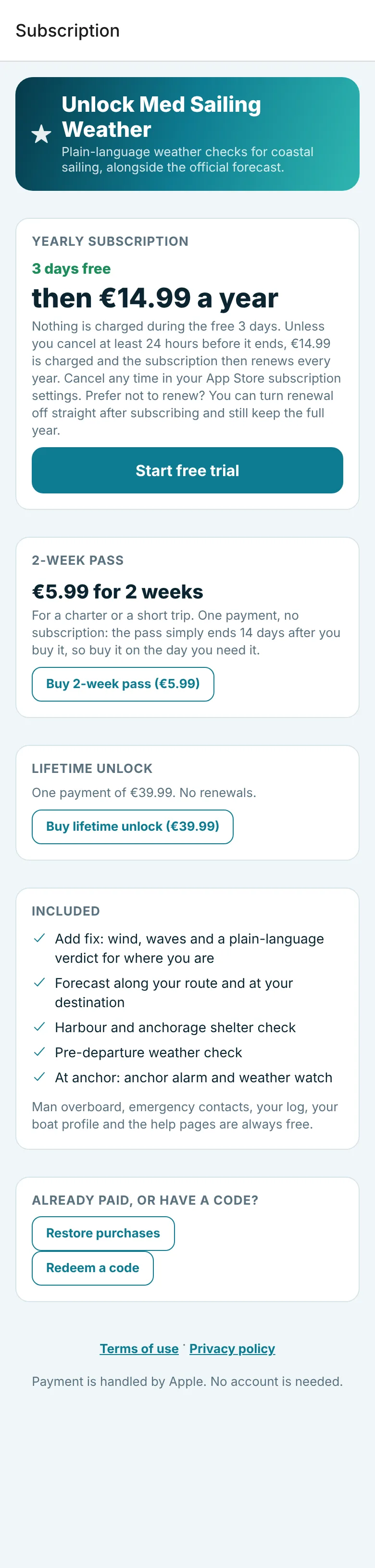
The app is free to download. New users get a 3-day free trial, then a yearly subscription of €14.99 a year. For a charter or a short trip there is a 2-week pass for €5.99, which does not renew: it ends 14 days after you buy it, so buy it on the day you need it. If you prefer to pay once, there is also a lifetime unlock for €39.99 with no renewals. Prices outside the euro area are set by Apple and Google in your local currency, and the exact price is always shown on the subscription screen before you confirm. To start, tap Start your free trial on the Dashboard, or tap any feature that is part of the subscription.
- Always free: man overboard, emergency contacts, your log, your boat profile and the help pages. An anchor watch that is already running also stays reachable, so it can always be seen and stopped.
- Part of the subscription: adding and editing fixes, the forecast, the harbour check, the pre-departure check, and the anchor alarm and weather watch.
- Cancelling: the subscription renews every year until you cancel it in your App Store or Google Play subscription settings, at least 24 hours before the renewal date. Cancel before the free trial ends and nothing is charged. You can turn renewal off straight after subscribing and still keep the full year. On the Boat tab, tap Subscription, then Manage or cancel subscription.
- New phone or reinstall: sign in to the same Apple or Google account and tap Restore purchases on the subscription screen.
- A code: if you were given a code, tap Redeem a code on the subscription screen.
- At sea: the app checks the subscription with the store when it has a signal, and keeps working offline in between.
21. Your data and privacy
- No account, no sign-in, no tracking.
- Your boat profile, fixes, log and passage plans are stored only on your phone. Deleting the app deletes them.
- The anchor alarm and weather watch use your location in the background only while you have them switched on. The positions and barometer readings stay on the phone; only the anchorage position is sent for the forecast.
- Subscriptions are bought and paid through Apple or Google. The app never sees payment details.
- To fetch weather and map data, the app sends positions (and nothing that identifies you) to public services: Open-Meteo for forecasts and pressure, aviationweather.gov for live airport observations, and OpenStreetMap services for place names, harbours and map tiles, including OpenSeaMap for sea marks.
The full privacy policy has the details.